Why ALTA Surveys Matter for Projects in Alabaster & Chelsea

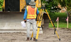
Professional land surveyor on-site with equipment at a commercial construction area—highlighting the role of ALTA Survey in Alabama real estate development.

Launching a commercial project in Alabaster or Chelsea? One of the smartest first moves you can make is securing an ALTA Survey. These growing cities in Shelby County are buzzing with new development, but beneath the surface, property lines, easements, and legal access points can get complicated fast. An ALTA Survey helps you uncover those details early, so you can move forward with confidence—no surprises, no setbacks.

What Is an ALTA Survey? (And What It Includes)

An ALTA/NSPS Land Title Survey is a highly detailed survey used in commercial real estate. It meets national standards set by the American Land Title Association and the National Society of Professional Surveyors.

🔍 It Includes:

  • Boundary lines
  • Easements and rights-of-way
  • Access routes and driveways
  • Visible improvements (buildings, utilities, fences)
  • Encroachments or potential zoning conflicts

Unlike a simple boundary survey, an ALTA Survey goes deep—linking what’s on the ground to what’s recorded in the legal title.

When an ALTA Survey Is Required 

In both Alabaster and Chelsea, an ALTA Survey is often required when:

1. You’re Buying or Selling Commercial Property

It gives buyers and lenders a complete picture of the property’s legal and physical condition.

2. You’re Getting Title Insurance

Most title companies will not issue a policy without a current ALTA Survey, especially if it’s a high-value or complex property.

3. You’re Planning Construction or Redevelopment

If you’re expanding a building, adding a parking lot, or starting new construction, you need to know where setbacks, easements, and utilities lie.

Local Land and Zoning Factors That Make ALTA Surveys Essential

🏘️ Rapid Subdivision Growth

Much of the land in Alabaster and Chelsea was once rural or agricultural. As areas are rezoned and subdivided, outdated records can clash with modern development plans.

🚧 Shared Access and Utility Easements

Many commercial lots in these cities share access roads, utility paths, or drainage systems. An ALTA Survey can uncover these details—before they turn into costly surprises.

🗂️ City Requirements for Permits

Local municipalities often require an ALTA Survey as part of the approval process for site plans, drainage reports, or zoning applications.

Risks of Skipping an ALTA Survey in Shelby County

Some developers try to save time or money by skipping this step. But it usually costs more in the end.

⚠️ What Can Go Wrong:

  • You find out after closing that a neighbor’s fence is on your property
  • A utility company has access rights you didn’t know about
  • You’re delayed because your site plan doesn’t meet zoning setbacks
  • A title insurer won’t move forward without more data

Avoiding these problems is exactly what an ALTA Survey is designed for.

Working with a Local Surveyor Familiar with Alabaster and Chelsea

Hiring a licensed land surveyor who knows Shelby County is key. They’ll be familiar with:

  • Local zoning rules
  • Recent plats and records
  • Common easement setups
  • Municipality-specific requirements

✅ Before hiring, ask:

  • Have you worked in Alabaster or Chelsea before?
  • Can you coordinate with our title company or lender?
  • What’s your average turnaround time?
  • Will you provide digital CAD files if needed?

A knowledgeable surveyor saves time, reduces risk, and helps your project move forward smoothly.

author avatar
Surveyor

More Posts

Two construction surveyors using a GNSS rover and field notebook under dense tree canopy showing RTK signal challenges
land surveyor
Surveyor

When RTK Drops, Here’s How Construction Surveyors Recover

If you’ve worked on a job site, you already know how unpredictable the field can be—especially for construction surveyors working under tree cover or in remote areas. One minute your RTK system is locked in; the next, your signal drops out and your GPS rover can’t hold a fix.  When

Read More »
Homeowners meeting with a land surveyor during a boundary line survey to review property boundaries
boundary surveying
Surveyor

The ‘Stakes Moved’ Debate and the Boundary Line Survey Fix

It started with a viral post: two neighbors arguing because one claimed the other had “moved the stakes.” The comments exploded—some said fences show the real property line, others insisted it’s wherever the metal pins are buried. The truth? None of them were completely right. When emotions run high and

Read More »
FEMA-style flood map overlay with property survey parcel lines showing high-risk flood zones
boundary surveying
Surveyor

Property Survey: How to Check Flood Risk First

Decatur is no stranger to water. With the Tennessee River and Wheeler Lake shaping the city’s edges, flood risk is always part of the conversation when it comes to land and property. Before you order a property survey for a new build, a home purchase, or an insurance requirement, it

Read More »
Land surveyor using a total station to perform a boundary survey after heavy rains near a residential property
boundary surveying
Surveyor

Why Every Boundary Survey Matters After Heavy Rains

When heavy storms sweep across Central Alabama, homeowners in Vestavia Hills feel the impact right away. Flash floods, steep driveways, and shifting soil can leave properties looking different overnight. That is why a boundary survey becomes more important after a storm than many people realize. It’s not only about knowing

Read More »
Lakefront homes with docks where a closing survey helps confirm property boundaries
boundary surveying
Surveyor

Closing Survey Essentials Every Homebuyer Should Know

Buying a lakefront home sounds like a dream. The views, the boat dock, the weekend gatherings—it all adds up to a lifestyle many people want. But before you rush into closing on a property, there’s one step you cannot skip: the closing survey. This document, prepared by a licensed land

Read More »
Aerial view of an industrial park showing property boundaries and infrastructure, illustrating the importance of an ALTA Survey for accurate development planning.
alta survey
Surveyor

Why an ALTA Survey Is Step One for New Projects

When news broke that the U.S. Space Command headquarters is finally moving to Redstone Arsenal, Madison and Huntsville leaders called it a win for the region. Over the next several years, thousands of jobs, federal contracts, and new construction projects will follow. Excitement is high, but before any developer puts

Read More »