Buying a home is one of the biggest investments you’ll ever make. In Huntsville, Alabama, where the housing market is booming, it’s more important than ever to be sure of what you’re buying. One smart step many homebuyers overlook is getting a property survey before closing the deal.
This guide will explain what a property survey is, why you might need one, how much it costs, and how it protects you from future issues.
Why Property Surveys Matter in Huntsville’s Hot Housing Market
Growth of Residential Real Estate in Huntsville
Huntsville is growing fast. With new homes popping up across the city, it’s easy for property lines and land details to get blurred. As a homebuyer, a survey ensures you know exactly where your property begins and ends.
Common Property Disputes and Legal Challenges
Without a survey, you could face problems like:
- Neighbors building on your land
- Disagreements about fences or driveways
- Legal trouble when you try to sell later
A survey clears up these risks before they become expensive mistakes.
What is a Property Survey?
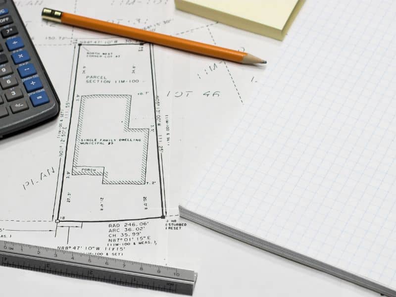
A property survey is a map created by a licensed surveyor. It shows the exact boundaries, size, and features of the land you’re buying. It also notes things like easements, slopes, and fences.
What’s Included in a Survey
Most surveys include:
- Boundary lines and measurements
- Location of buildings, fences, and driveways
- Easements or shared property features
- Utility lines or underground pipes
How It’s Different From an Appraisal or Inspection
- An appraisal estimates the value of the home.
- A home inspection looks at the condition of the building.
- A property survey focuses on land and legal boundaries.
When and Why You Need a Property Survey Before Closing
1. To Confirm Boundaries and Avoid Encroachment
You’ll know exactly where your property ends. That way, you won’t accidentally build something on your neighbor’s land—or vice versa.
2. To Follow Zoning and Building Codes
Surveys help you and the city check if the property follows local laws. This is useful if you plan to build a fence, deck, or addition later.
3. To Satisfy Your Mortgage Lender or Title Company
Some lenders or title companies may require a recent survey to complete the home loan or issue title insurance.
Types of Property Surveys for Homebuyers
- Boundary Survey. This is the most common for homebuyers. It marks property lines and checks for encroachments like fences or buildings that cross into your land.
- Mortgage Location Survey. This simpler version is often used by banks. It shows the home’s position on the land but doesn’t include deep legal checks.
- ALTA/NSPS Survey. For high-value or commercial properties, this survey includes detailed legal and title information.
- Topographic Survey. If you’re planning to build on the land, a topographic survey maps the shape of the land, showing hills, dips, and drainage.
How to Read and Understand a Property Survey

Legal Descriptions and Drawings
The survey includes a legal description—words that define the land’s location and size. You’ll also get a drawing that shows the layout of the lot and structures.
Common Symbols Explained
- Solid lines = boundary lines
- Dotted lines = easements
- Arrows = slopes or direction of drainage
- X or crosses = survey markers
Questions to Ask Your Surveyor
- Are there any boundary problems?
- Are buildings or fences within legal limits?
- Are there any easements I should know about?
Average Cost of a Property Survey in Huntsville, AL
What Affects the Cost?
- Size of the property
- Type of survey needed
- Terrain (flat land is easier and cheaper to survey)
- Time required to complete the work
Estimated Price Ranges
| Survey Type | Price Range |
| Boundary Survey | $350 – $600 |
| Mortgage Location Survey | $200 – $400 |
| ALTA/NSPS Survey | $1,000 – $2,000+ |
| Topographic Survey | $500 – $1,200 |
Note: These are estimates—get a local quote for exact pricing.
Choosing a Qualified Property Surveyor in Huntsville
Licensing and Certification
Always hire a surveyor licensed in Alabama. You can check their status on the Alabama Board of Licensure for Professional Engineers and Land Surveyors website.
How to Find and Vet Surveyors
- Ask your real estate agent or lender for recommendations
- Read Google or Yelp reviews
- Ask how long they’ve worked in Huntsville
Understand Their Report Timeline
Most surveys take 3–10 days, depending on the complexity of the job.
What Happens If You Skip the Survey?
Real-Life Risks
Without a survey, you might:
- Buy less land than you think
- Inherit a neighbor’s fence problem
- Have trouble selling the house later
Impact on Resale and Remodeling Plans
Future buyers may demand a survey. Or, you might get denied for a building permit because the city doesn’t know where your land ends.
FAQs
1. Is a Property Survey Required in Alabama?
Not always—but lenders and title insurers often require it, and it’s strongly recommended.
2. How Long Does It Take?
Most surveys take a few days to a week, depending on the type and property size.
3. Can I Use the Seller’s Old Survey?
Sometimes, but only if it’s recent and no changes were made to the land or buildings.


