Why Topographic Surveys Matter for Land Development

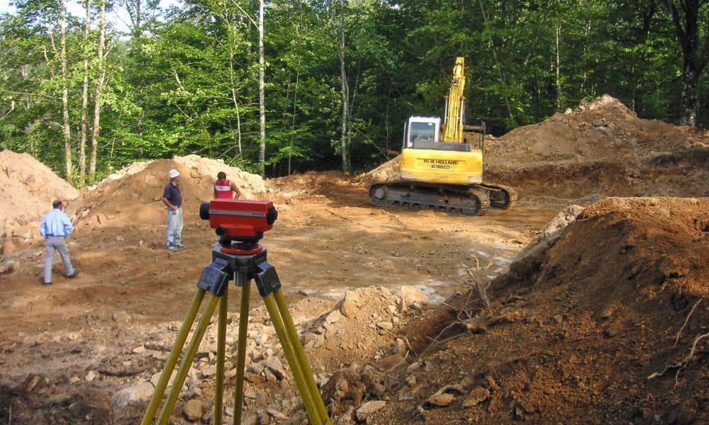
Surveyor using a total station on uneven terrain to collect elevation data for topographic surveys before site development

Alabama is growing, with more homes, buildings, and roads being built every year. Before any construction can begin, it’s important to understand what the land looks like. A topographic survey helps with that.

Topographic surveys show the shape of the land, including hills, slopes, trees, and man-made features. They are a key part of planning for safe and successful land development in Alabama.

What Is a Topographic Survey?

A topographic survey is a type of land survey that measures elevation and surface features. Unlike a boundary survey, which shows where property lines are, a topographic survey shows how high or low the ground is and what’s on it.

Surveyors use tools like GPS, total stations, or even drones to collect data. Then they create a map that shows things like:

  • Hills and low spots
  • Roads, fences, or buildings
  • Trees and drainage areas

This map helps engineers and builders make smart decisions about the land.

Why Topographic Surveys Matter in Alabama

Better Site Planning

When builders and engineers know how the land slopes or changes, they can make better plans. For example, it helps decide where to put buildings, driveways, and parking lots. Many professionals rely on a site elevation survey to evaluate slope conditions, determine cut-and-fill needs, and plan for safe, cost-effective construction.

Preventing Drainage Problems

Alabama gets a lot of rain. If water can’t drain properly, it can cause flooding or damage. A topographic survey shows where the water will go, which helps plan good drainage systems. This is especially important in areas that flood often.

Getting Permits

Many cities and counties in Alabama require a topographic survey before giving a building permit. The survey gives clear information that makes it easier to get approval from local governments.

Saving Time and Money

Doing a survey early in a project helps avoid surprises later. Builders can see problems before construction starts, which saves time and money. It also helps avoid delays and mistakes.

Where These Surveys Are Used in Alabama

Topographic surveys are helpful for many kinds of projects, such as:

  • New neighborhoods in Huntsville or Mobile
  • Stores or office buildings in Montgomery
  • Road improvements and bridges
  • Planning utilities like power lines and sewer systems

Hiring a Licensed Surveyor

To get the most accurate results, it’s important to work with a licensed land surveyor in Alabama. These professionals are trained and follow state rules.

Surveyors will give you a map and data files showing the land’s features. These can be used by architects, engineers, and construction teams to plan the project.

Final Thoughts

A topographic survey is a smart first step in any land development project. It helps builders understand the land, plan properly, and avoid problems. In Alabama, where the land can vary a lot and rules can differ by area, having this survey makes a big difference.

Whether you’re building a home, a shopping center, or a public road, a topographic survey can save time, lower costs, and help you follow local rules. It’s a valuable tool for anyone developing land in Alabama.


author avatar
Surveyor

More Posts

Two construction surveyors using a GNSS rover and field notebook under dense tree canopy showing RTK signal challenges
land surveyor
Surveyor

When RTK Drops, Here’s How Construction Surveyors Recover

If you’ve worked on a job site, you already know how unpredictable the field can be—especially for construction surveyors working under tree cover or in remote areas. One minute your RTK system is locked in; the next, your signal drops out and your GPS rover can’t hold a fix.  When

Read More »
Homeowners meeting with a land surveyor during a boundary line survey to review property boundaries
boundary surveying
Surveyor

The ‘Stakes Moved’ Debate and the Boundary Line Survey Fix

It started with a viral post: two neighbors arguing because one claimed the other had “moved the stakes.” The comments exploded—some said fences show the real property line, others insisted it’s wherever the metal pins are buried. The truth? None of them were completely right. When emotions run high and

Read More »
FEMA-style flood map overlay with property survey parcel lines showing high-risk flood zones
boundary surveying
Surveyor

Property Survey: How to Check Flood Risk First

Decatur is no stranger to water. With the Tennessee River and Wheeler Lake shaping the city’s edges, flood risk is always part of the conversation when it comes to land and property. Before you order a property survey for a new build, a home purchase, or an insurance requirement, it

Read More »
Land surveyor using a total station to perform a boundary survey after heavy rains near a residential property
boundary surveying
Surveyor

Why Every Boundary Survey Matters After Heavy Rains

When heavy storms sweep across Central Alabama, homeowners in Vestavia Hills feel the impact right away. Flash floods, steep driveways, and shifting soil can leave properties looking different overnight. That is why a boundary survey becomes more important after a storm than many people realize. It’s not only about knowing

Read More »
Lakefront homes with docks where a closing survey helps confirm property boundaries
boundary surveying
Surveyor

Closing Survey Essentials Every Homebuyer Should Know

Buying a lakefront home sounds like a dream. The views, the boat dock, the weekend gatherings—it all adds up to a lifestyle many people want. But before you rush into closing on a property, there’s one step you cannot skip: the closing survey. This document, prepared by a licensed land

Read More »
Aerial view of an industrial park showing property boundaries and infrastructure, illustrating the importance of an ALTA Survey for accurate development planning.
alta survey
Surveyor

Why an ALTA Survey Is Step One for New Projects

When news broke that the U.S. Space Command headquarters is finally moving to Redstone Arsenal, Madison and Huntsville leaders called it a win for the region. Over the next several years, thousands of jobs, federal contracts, and new construction projects will follow. Excitement is high, but before any developer puts

Read More »