How To Find Your Property On FEMA’s Flood Insurance Rate Maps

What are FEMA flood maps?
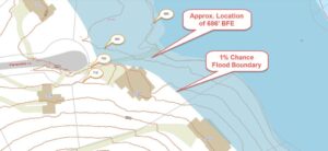
FEMA’s Flood Insurance Rate Maps (FIRMs) or just Flood Maps are provided after a flood risk assessment has been completed or updated for a community.  This study is known as a Flood Insurance Study.  The FIRM gives you the Base Flood Elevations (BFEs) and insurance risk zones in addition to floodplain boundaries.  The FIRM may also show a delineation of the regulatory floodway.

Once the “insurance risk zone”  (commonly referred to as the flood zone) is determined, actuarial rates, based on these risk zones, are then applied for newly constructed, substantially approved, and substantially damaged buildings.  FEMA uses these rates to determine the insurance rate you will pay for flood insurance

FEMA’s Digital Flood Maps

FEMA discontinued the production and distribution of paper flood maps in 2009 as part of its Digital Vision Initiative. This affected all the Flood Maps, boundary information, and study reports. However, clients can still view the products for free through their website or buy them in digital format.

To view these flood maps online, go to FEMA’s Map Service Center and key in your address (hi-lited area shown here) search for your home.  This will prompt you to then select the map that covers your area.  The Flood Maps are somewhat cumbersome to use online. It is best to go through the tutorial on the bottom right of the address search page for an easier and more effective use of the GIS map.

author avatar
Surveyor

More Posts

Property Survey Guide for Huntsville Homebuyers (2025)

Buying a home is one of the biggest investments you’ll ever make. In Huntsville, Alabama, where the housing market is booming, it’s more important than ever to be sure of what you’re buying. One smart step many homebuyers overlook is getting a property survey before closing the deal. This guide

Read More »

Why ALTA Surveys Matter for Projects in Alabaster & Chelsea

Launching a commercial project in Alabaster or Chelsea? One of the smartest first moves you can make is securing an ALTA Survey. These growing cities in Shelby County are buzzing with new development, but beneath the surface, property lines, easements, and legal access points can get complicated fast. An ALTA

Read More »

LiDAR Mapping Services in Auburn, AL: Costs, Process & Local Use Cases

If you’ve worked in development, surveying, or land planning in Auburn, you’ve likely come across LiDAR mapping. It’s a powerful technology that’s changing how professionals analyze and understand the land. But what exactly is it? LiDAR stands for Light Detection and Ranging. It’s a cutting-edge mapping method that uses laser

Read More »

Remote Sensing 101: How LiDAR Works in Land Surveying

Mapping the land has come a long way. What used to take weeks with measuring tapes and tripods can now be done in a single day—thanks to advanced technology like remote sensing. One of the most powerful tools in this field today is LiDAR, and it’s changing the way we

Read More »

Land Surveying in Alabama: Everything You Need to Know

Buying or developing land is exciting, but it also comes with risks. If you don’t know exactly where your property lines are, you could face legal issues, construction delays, or costly mistakes. That’s where land surveying comes in. A professional land surveyor ensures that you understand your land’s boundaries, topography,

Read More »