Before you break ground on your dream home or start planning a major development, there’s one step that often gets overlooked—but could save you thousands down the road: the topographic survey.
Whether you’re a homeowner looking to add a new deck or a developer preparing for site grading, understanding the shape, slope, and surface of your land is critical. That’s exactly what a topographic survey reveals. It’s not just for engineers—it’s for anyone who wants to build smart, safe, and by the book.
In this guide, we’ll walk you through what a topographic survey is, when you need one, what it includes, and why it’s a must-have for any construction or land improvement project in 2025.
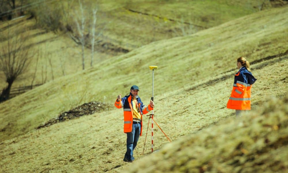
What Is a Topographic Survey?
Let’s start with the basics. A topographic survey is a type of land survey that maps out the natural and built features on a property, including changes in elevation. It shows you the hills, dips, drainage paths, and physical elements like trees, buildings, fences, and driveways.
Imagine it as a 3D model of your property on paper. It helps you see how water flows, how steep certain areas are, and what obstacles exist—critical details for any builder or planner.
What Does It Measure?
A topographic survey captures:
- Contour lines to show elevation changes
- Man-made structures like buildings, retaining walls, and driveways
- Natural features like trees, hills, and drainage areas
- Slopes and grades to plan for runoff and foundation support
Why Topographic Surveys Matter in Land Development
Here’s the deal: You can’t build responsibly if you don’t understand the lay of the land. That’s where a topographic survey shines.
Helps with Grading and Drainage
If you don’t plan for water runoff, you could end up with a flooded basement or soil erosion. A topographic survey guides:
- Proper site grading
- Drainage system placement
- Water flow management to prevent future issues
Supports Engineering and Architecture
Designing a home or commercial building isn’t just about aesthetics—it’s about placement and structure. With a topographic survey, engineers and architects can:
- Choose the best spot for construction
- Adjust designs to the terrain
- Avoid costly surprises during excavation
When Should You Get a Topographic Survey?
Timing matters. These are the most common moments when ordering a survey is smart:
- Before construction or home additions
- When applying for a building permit
- During land purchase or real estate due diligence
- Before site grading or landscaping
- For flood mitigation or drainage concerns
If your project involves slopes, stormwater, or structural design, a topographic survey is more than helpful—it’s essential.
What Does a Topographic Survey Include?
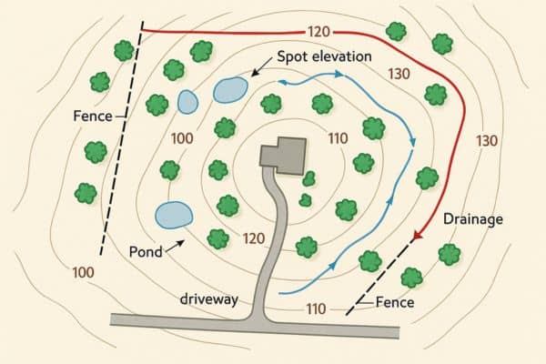
A proper topographic survey doesn’t just come with a map. It’s packed with data:
- Contour elevations (usually shown in intervals like 1 foot or 2 feet)
- Natural features: trees, slopes, ponds
- Man-made features: fences, curbs, driveways, buildings
- Drainage direction and elevation points
- Utility lines and site-specific details
This map becomes the foundation for your site plan or construction design.
How Much Does a Topographic Survey Cost in 2025?
In 2025, you can expect to pay:
- $800–$2,500 for a standard residential lot
- $2,500–$10,000+ for larger or complex sites
The final cost depends on:
- Property size and terrain
- Access and vegetation (heavily wooded areas cost more)
- Required detail level
- Surveyor’s experience and tools (e.g., drones or LiDAR)
What Tools Are Used in a Topographic Survey?
Today’s topographic surveys blend time-tested techniques with modern tech to give you incredibly accurate results.
Standard Equipment Includes:
- Total Stations: Measure angles and distances on the site
- GPS Units: Provide real-time coordinates, especially useful for large or open areas
- Measuring Rods & Levels: For determining elevation changes across the property
High-Tech Tools:
- Drones (UAVs): Great for large or hard-to-reach areas, they quickly capture aerial images and elevation data
- 3D Laser Scanners: Capture dense surface data with precision
- LiDAR Technology: Sends laser pulses to detect subtle changes in terrain, ideal for sites with dense vegetation or environmental sensitivity
Topographic Survey vs. Boundary Survey: What’s the Difference?
These two types of surveys are often confused—but they serve different purposes.
| Survey Type | Focus Area |
| Topographic Survey | Measures land features and elevation |
| Boundary Survey | Determines legal property lines and corners |
If you’re building, you likely need both. The boundary survey ensures you’re building on your own land, while the topographic survey ensures you’re building correctly on the terrain.
Real-World Examples: Why It Pays to Get a Topographic Survey
Here are a few relatable scenarios where a topographic survey proved invaluable:
🏠 Homeowner in Auburn, AL
A property owner planned a patio extension but didn’t realize the rear yard sloped downward significantly. A topographic survey revealed drainage issues, prompting the installation of a proper retaining wall before construction began.
🏢 Commercial Developer in Montgomery, AL
Before developing a strip mall, the survey revealed low-lying sections that would collect water. The data was used to redesign the grading plan, saving thousands in potential water damage repairs later.
Mistakes to Avoid When Ordering a Topographic Survey
Don’t fall into these common traps:
- Not defining your needs clearly: Always tell the surveyor what you plan to do (build, subdivide, apply for permits) so they know what to include.
- Hiring someone unlicensed: Some freelancers or companies may offer cheaper services—but their work may not meet legal or permitting standards.
- Skipping it entirely: Trying to save money by skipping a topographic survey often leads to delays, change orders, or costly design corrections down the line.
Conclusion
In 2025, land development—whether residential or commercial—is more precise than ever. A topographic survey gives you the clear, reliable data needed to design safely, build smartly, and avoid regulatory issues.
Whether you’re planning a home addition in Huntsville, AL or managing a commercial buildout across multiple acres, understanding your land is the first step. Local jurisdictions, including Huntsville’s planning department, often require detailed elevation data for permit approval—making topographic surveys not just helpful, but essential.
So, before you design your foundation or submit that permit application, make sure your plans are grounded—literally and legally—with a topographic survey.
FAQs:
Q1: Do I need a topographic survey for a small home addition?
A: If your addition affects the site’s grading, water flow, or elevation, it’s a good idea—and may be required by your local building department.
Q2: Can I use an old topographic survey?
A: It depends. Land doesn’t change much, but construction, landscaping, or erosion might affect accuracy. It’s best to verify with your surveyor.
Q3: Is a topographic survey required by law?
A: Not always, but local zoning or permitting authorities often require one before approving plans for grading or new structures.
Q4: How long does the process take?
A: Most residential surveys take 1–2 weeks, while commercial or complex sites may take longer depending on size and scope.
Q5: Will this survey show underground utilities?
A: Only if that service is requested. Some firms offer utility locating as an add-on.
Q6: Who should I hire for a topographic survey?
A: A licensed land surveyor with experience in topographic work and access to modern tools like drones or LiDAR is ideal.

